Guest Blog by Eric Aldrich
The following is part of a series of recommended Sky Island hikes. Be safe, have fun, and leave no trace.
If you’ve got all day — or a couple of days — a hike out to Madrona Ranger Station provides a glimpse into the history of Saguaro National Park. Located east of Tucson and several miles southeast of the current park visitor center, Madrona was once the gateway to the Rincon Mountains. It was the launching point for hikes to Manning Camp on Mt. Mica and a destination in its own right.
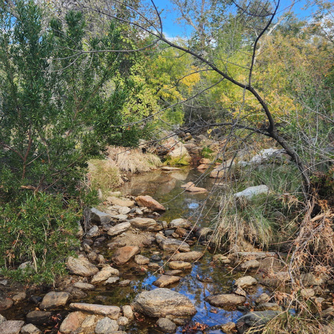
Much like Sabino Canyon in the Catalina Mountains, Chiminea Canyon, which runs through Madrona, hosts sycamores, frogs, and all the life of a riparian ecosystem. It’s easy to see why the National Park Service would choose Madrona for the entry point. Sadly, Madrona was only accessible via an easement through the privately owned X-9 Ranch, and conflicts between the rancher, Henry W. Jackson, and the public escalated until Jackson restricted the easement to only allow NPS staff to reach Madrona via the
While rumors claim that Jackson revoked the easement to create a gated community and give residents near-exclusive access to a prime part of Saguaro National Park (then Saguaro National Monument), newspapers at the time tell a much different story. They report that people driving down X-9 Road shot up Jackson’s water tanks, released his cattle, destroyed his property, and even shot a horse out from under a girl who was riding it. Repeated unsafe and destructive incidents drove the rancher to close his land. Jackson floated various options over the years to restore public access to Madrona, including allowing the county to build a paved road and allowing people to traverse the X-9 on foot. However, foot-only access was considered discriminatory to people with limited mobility, and the county didn’t want to pave the road, so those talks petered out.
Madrona’s story highlights conflicts between the rights of private landowners and the public’s rights to access public land. Over the years, groups ranging from the Southern Arizona Hiking Club, Tucson Rod and Gun Club, Tucson Bird Alliance, and Sierra Club have worked to restore public access to Madrona without success. In the 1970s and 1980s, Jackson sold off 40+ acre lots to create the X-9 Ranch gated community, featuring homes priced over $1 million each and an armed guard at the gate. Dr. Andrew Weil, the health guru, once lived there.
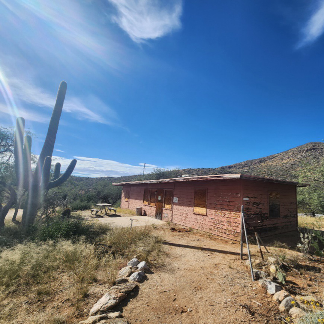
Madrona currently functions as a staging area for NPS staff and authorized researchers to access the backcountry of Saguaro National Park. An outbreak of Hantavirus condemned the buildings in the 1990s. The nearest trailhead is about nine miles away, which means that not many people hike out there. However, if you enjoy backpacking or long, rambling day hikes, then Madrona remains accessible to you.
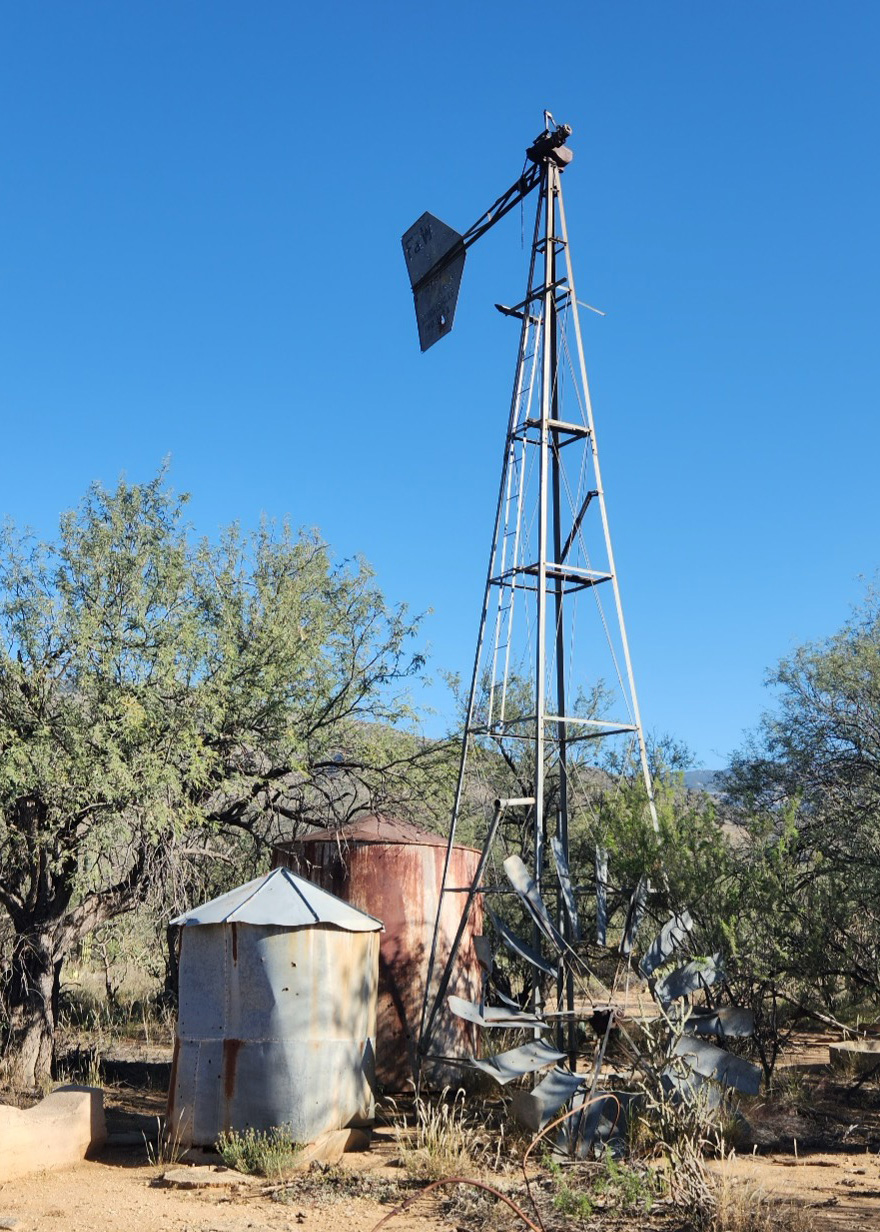
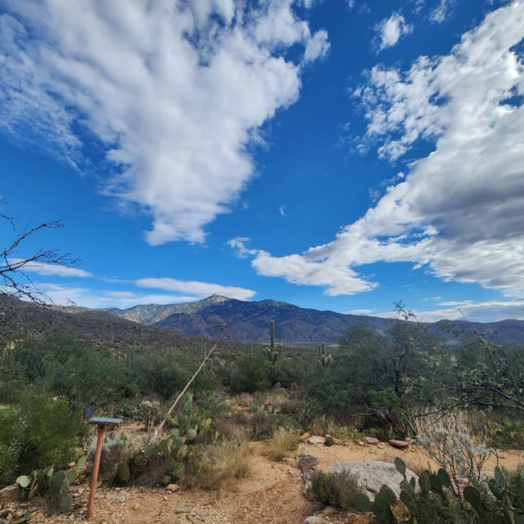
On my most recent trip, my partner and I set out around 7:30 a.m. on a cool, sunny November morning. To reach the station, we started at the Loma Alta Trailhead and headed east on the Hope Camp Trail for 2.3 miles until we reached the junction with the Quilter Trail. Hope Camp Trail is wide, well maintained, and popular with mountain bikers. By going past the Quilter Trail junction a short distance, we arrived at a disused ranching site with a windmill, tanks, and foundation. The windmill blades sit at the base of the stand, and the fin reads “F. Rondstadt HDW CO, Tucson.”
Though Google’s motto is “don’t be evil,” Google Maps sometimes fails to live up to this ideal. For example, Google Maps incorrectly indicates that a trail runs directly from the old ranching site to Madrona Station, which would make the entire trip only about 13 miles. And it says that it’s the Douglas Springs Trail. But if you’re familiar with Saguaro National Park, you’ll recognize that Douglas Springs Trail isn’t in that area. So it’s pretty bad for Google Maps to show a route into the backcountry that doesn’t exist. People could get lost or hurt.
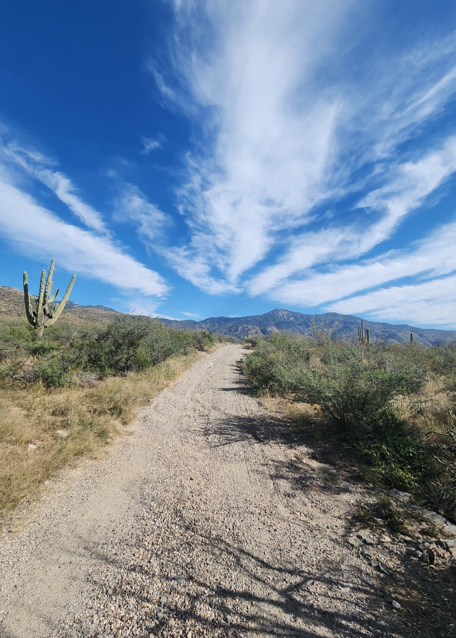
In the non-digital world, it’s actually the Quilter Trail that will take you most of the way to Madrona. On our excursion, we met an eastern patch-nosed snake and enjoyed some flavorful hackberries. The trail tracks northeast for 4.4 miles with Rincon Peak dominating the horizon. It’s named after John “Jake” Quilter, a member of the Saguaro trail crew who passed away suddenly while working in the area in 2006. A plaque in his memory marks the intersection with Hope Camp Trail.
After gaining modest elevation, the Quilter Trail intersects with the Manning Camp Trail, which can take you north to Manning Camp and the top of the mountain or south to Madrona Ranger Station. The southward segment slopes down beside Chiminea Creek for 1.9 miles before reaching the station. Losing all the elevation gained on Quilter means regaining it on the way back. But with wide steps, the trail is well maintained and comfortable walking.
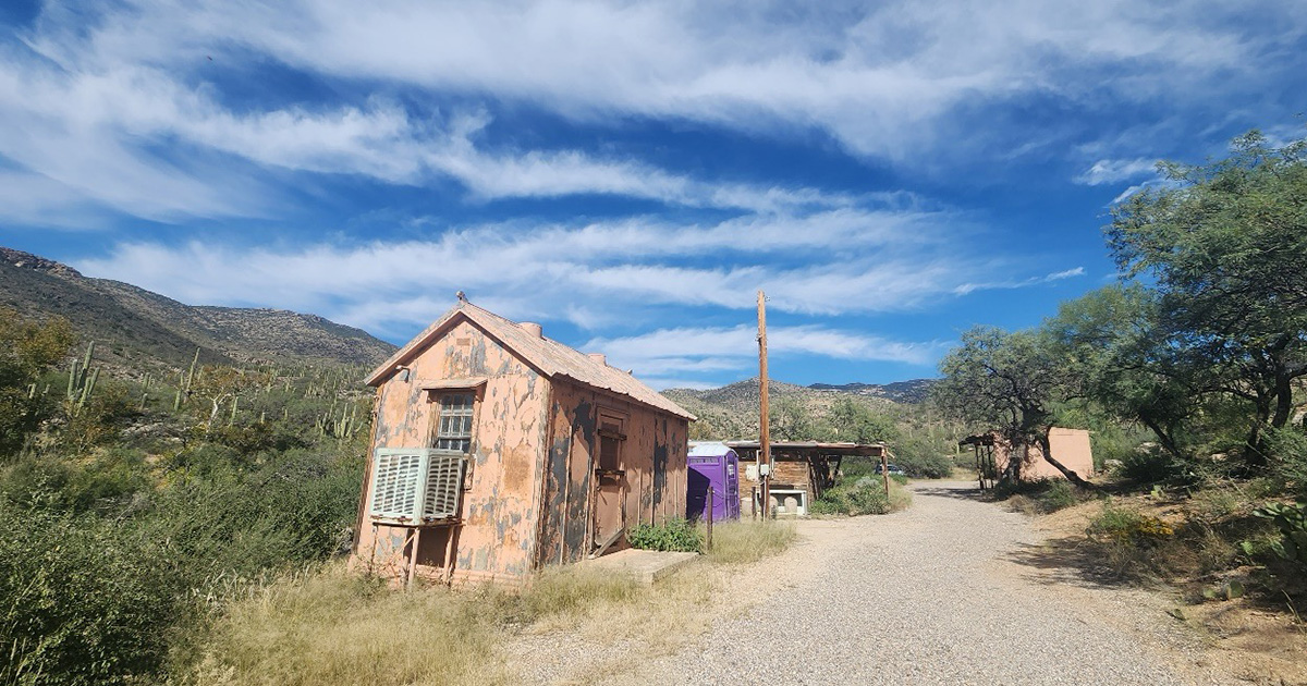
Four boarded-up buildings constitute the remaining structures of Madrona Ranger Station. There is also another modern storage building. If you follow the road as far as you can, you’ll reach a gate separating Saguaro National Park from the privately owned X-9 Ranch. Featuring a creepy surveillance sign, the gate is a landmark you may as well miss. Instead, spend time observing life in the pools. From insects to amphibians to riparian plants, water brings so much color and life into the desert. We ate lunch in a loose cloud of blue butterflies.
An important disclaimer: Because of their remoteness, Madrona’s pools provide refuge to rare and endangered species. For example, the lowland leopard frog, once found in creeks and springs throughout the Sky Islands, has declined due to disease and the introduction of non-native species like bullfrogs. The leopard frogs call Madrona home. On our most recent visit, the water levels were significantly lower than on my previous two trips, but I still spotted a large gray tadpole. Hundreds of butterflies and other insects swarmed the few pools, and in some places, enough water remained for a little downstream trickle. This is to say that you should take great care not to contaminate the water with sunscreen or other chemicals.
Again, it’s very important not to disrupt the ecosystem at Madrona Pools. If you visit, bring enough water for the entire trip. The pools are fragile. Rumor has it that the Arizona Trail was constructed to bypass the pools and reduce traffic in the area. There are spots suitable for camping along the Quilter Trail, so I wouldn’t advise anyone to actually camp at Madrona Station. And of course, no campfires are allowed in this sensitive low-desert area.
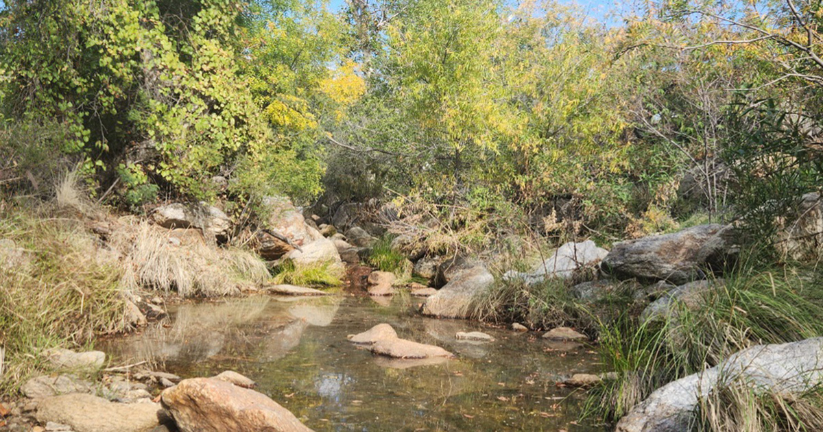
The sun set about a half hour before we returned to Loma Alta. At its most basic length, the total round-trip hike is 17.2 miles, but it can easily go longer with exploring. It should not be rushed. We rested at Madrona, beside one of the pools, and took our time observing the hundreds of water striders, boatmen bugs, butterflies, and dragonflies. Colder nights had coaxed gold and red into the sycamore leaves, and it was impossible to hurry away. It’s hard to accept that a luxury gated community cuts the Madrona area off from public access, but it’s easy to appreciate solitude in such a beautiful place.
Eric Aldrich is a Sky Island Alliance board member and lives in Tucson, Arizona. He teaches writing and literature at Pima Community College and is an assistant nonfiction editor at Terrain.org. His article “Eyes in the Wild” was published in BorderLore and explores SIA’s FotoFauna and Border Wildlife Study programs. Get more at ericaldrich.net.
Getting There
To reach the Loma Alta Trailhead, take I-10 East to Colossal Cave Road, Exit 279. Follow Colossal Cave Road to South Camino Loma Alta. The trailhead is located at the end of the road. See this Gaia map for a sense of the route to Madrona Ranger Station, and download the GPX file to your device in advance to navigate to the spot.