Did you know that we can identify fossil fuel emissions in the air by sampling annual plants and counting cars? Knowing where greenhouse gases are and at what concentrations can help policymakers fight climate change. All major cities in Arizona have developed action plans to reduce greenhouse gases, but they still lack quality data regarding carbon dioxide sources and the ability to monitor how well actions work. You can help!
This spring, Sky Island Alliance is partnering again with Northern Arizona University’s ACE Isotope Lab, Arizona State University’s Southwest Urban Corridor Integrated Field Lab, and Desert Botanical Garden in Phoenix to measure fossil fuel levels in Arizona’s three biggest cities. For this particular collaboration, our role is to contribute data specifically from Tucson. What we need are volunteers to help sample different places around town to understand which areas have the highest emissions.
Volunteer Opportunity #1: Traffic Counting (Ongoing)

Our first activity involves collecting vehicle data around Tucson to inform models tracking fossil fuel emissions across Arizona. We’ll be helping count traffic using the Hestia App. Hestia is a modeling approach used by Northern Arizona University that shows fossil fuel sources across cities at a highly precise scale. The data will allow city planners to identify emissions hotspots and monitor progress toward climate actions over time.
This is important since on-road activity is one of the largest sources of greenhouse gases and local pollution in large cities. However, for Hestia to run more effectively, more info is needed about how different types of vehicles are distributed at various road locations. We need volunteers to help gather this data. To get started, simply follow the steps below. You’re also invited to join one of our field trainings in Tucson if you’d like to walk through the steps in person, ask questions, and get practice with the app.
Have questions? Email Meagan Bethel or book a virtual meeting with her to discuss more.
Volunteer Opportunity #2: Plant Sampling (March – April)
Our second volunteer opportunity this spring involves collecting certain invasive annual plants around Tucson, so we can send them off to a lab for tissue analysis. When fossil fuels are burned in our communities, they leave an imprint on atmospheric carbon dioxide. Plants record their level of fossil fuel exposure in the radiocarbon content of their stems, leaves, and flowers. For annual plants — i.e. ones that will complete their entire lifecycle this spring — their tissues will have lower radiocarbon signatures in areas with higher fossil fuel emissions.
Learn more about how to help below. You can also watch our 2024 virtual training. We’ll be collecting plants throughout March and April, and after this training you’ll be ready to volunteer with confidence. You can also jump right in and follow the guide below. Either way, you’ll need to schedule a time to pick up sample envelopes and an assignment from the SIA office. Contact Meagan Bethel to arrange a time. Generally, our staff will be available on Wednesdays from 1-4 p.m. and Thursdays from 9 a.m. to noon.
Step 1: Join the iNaturalist Project
- Download iNaturalist from the Apple App Store or Google Play.
- Register to iNaturalist with a username and password.
- Click on Projects > Type SWIFL into the search box > Select SWIFL Annual Plant Radiocarbon Project S2025 (live March 1st)> Click Join.
- Make sure you enable the app to use location services while the app is open.
- Apple: Within the Settings gear box, go to Privacy & Security > Location Services > iNaturalist app > Turn location services On.
- Android: In Settings, go to Location, switch location On. Tap mode and select high accuracy.
- If asked to trust this project with hidden coordinates, select Yes for all observations.
Step 2: Collect & Record Plant Samples
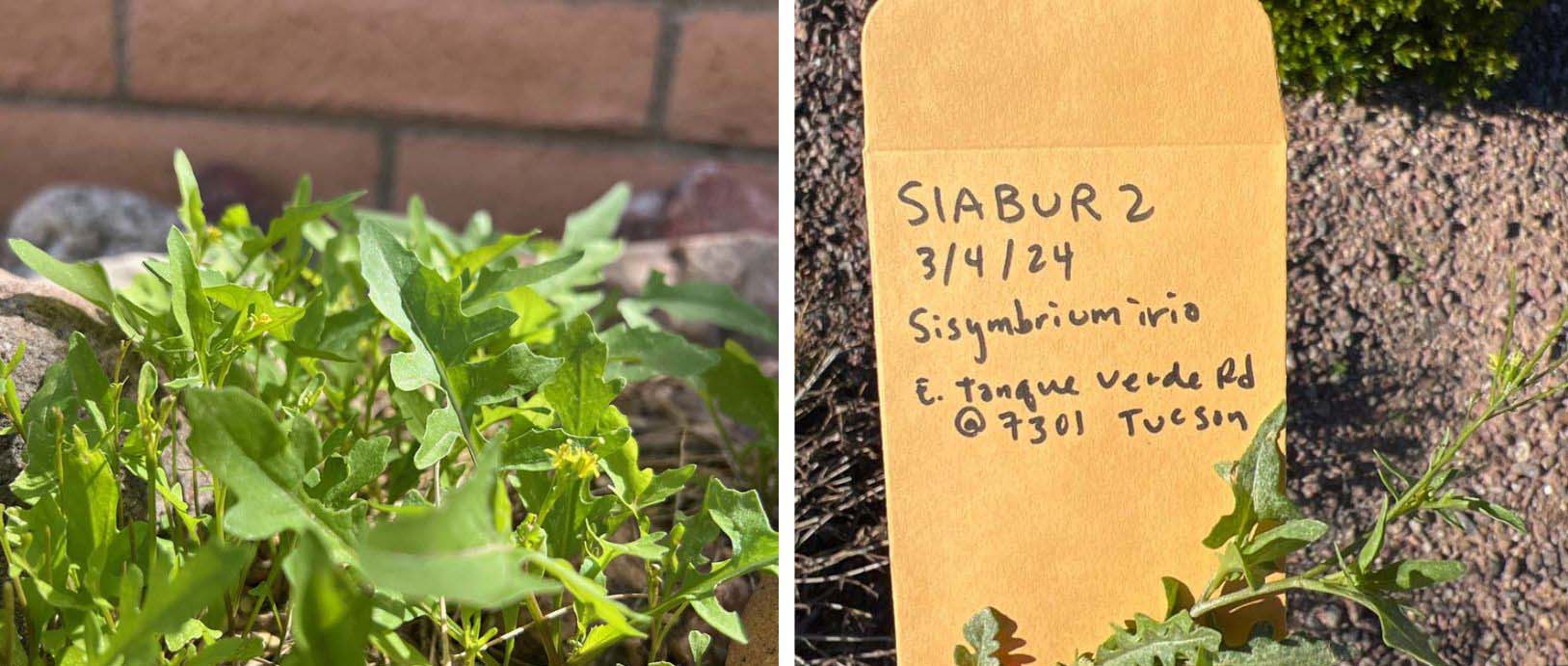
- Navigate to your assigned target location. There are 13 points at each location to check if there is an invasive annual plant. We recommend looking for London rocket (Sisumbrium irio). (Here’s a full list of annual plants the project will accept.)
- Your paper collection envelope will have a printed label, please fill out the following for each location, even if there is not a plant.
- Location of Point will be preprinted; please verify you are at the correct spot.
- Individual ID code:
- SIA + the first three letters of your last name
- Circle the distance away from center (50, 100, 250 meters)
- Circle the initial of cardinal direction (N, E, S, W, C for center point)
- For example: SIABUR50N, SIABUR100N, SIABUR250N)
- Date of collection
- Is there a plant at that location? Check Yes or No
- If yes: Scientific name of the plant
- If there is no plant, indicate that on the envelope and leave it empty. Move onto the next point.
- If there is an invasive annual:
- Open the iNaturalist app on your smartphone:
- Click Observe.
- Click on Camera and take a photo of the annual plant you found. Click the + at the top of the screen to add a second photo with the labeled collection envelope visible in the photo.
- Click What did you see? Select the plant you found based on iNaturalist’s suggestions.
- Click on the Location and verify that it’s accurate. If not, move the crosshairs to your location and click Save.
- In the Notes section of the observation, write your Individual ID code (example: SIABUR250E).
- Click Share to upload your sample to iNaturalist.
- Cut the plant sample, taking at least one stem segment with leaves the length of your index finger. If you pulled the invasive out by the roots, discard the roots and soil. Put the stem sample into a collection envelope.
- Move onto the next point
- Open the iNaturalist app on your smartphone:
- Check all 13 points and be sure to indicate on the envelope if there are no plants! Once done, you may move to the next Target Location to repeat this process.
Frequently Asked Questions