Sky Island Alliance created a Sky Island Springs Prioritization Tool to help land managers gain insight into the state of nearly 4,000 springs in southern Arizona. It is a database, conservation science model, and dynamic map that allows users to compare the relative conservation value, level of threat, and spatial isolation of springs from other perennial water sources in the region. By using our map explorer, users can learn how to compare the condition and risk of springs across public and private lands with best available data to guide the prioritization of springs for protection and restoration actions on the ground. Version 1.0 includes only springs in the U.S. portion of the Sky Island Region, but we plan to expand future versions to include springs in Mexico also.
Click here to download the Spring Prioritization Tool 1.0: SpringsTool_v1.0
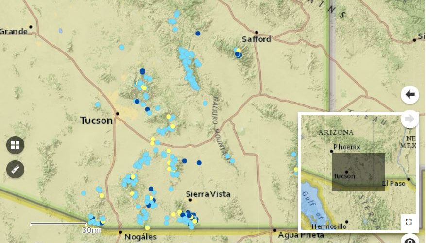
Pan and zoom with your mouse to explore the map. Click on a point, and then the small “>” arrow to see information about a particular spring. To view the map legend, click on the bottom left icon. To turn on and off other data layers, like Spring Threat Score, click on the icon that looks like a stack of papers. To share this map, click on the second from the right icon. For other base maps, click on the “four squares” icon on the left side of the map. You can view this full screen by clicking on the link above the map.
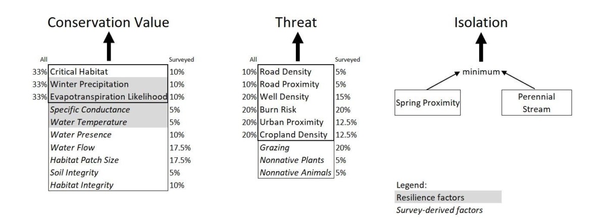
Variables used to calculate each score. Scores for all mapped springs are in the bold outlined boxes. Percentages reflect relative weights of variables used when calculating scores.
This project was funded by the Bureau of Reclamation and the Nina Mason Pulliam Charitable Trust.
The Spring Prioritization Tool 1.0 contains an Excel database of attributes for 3,891 springs and calculated scores for comparing relative spring conservation value, threat, and isolation from other water sources. It was developed to help land managers and conservation practitioners in the northern Sky Island Region (Southern Arizona) better understand the physical, biological, and social context for springs in their region and to aid the prioritization of conservation activities. The spreadsheet is called SpringTool_v1.0.xlsx and includes the following sheets:
Metadata: List of variable description, unit of measurement, scale of analysis, data source, date or version of data acquisition, hyperlink to data source, and notes on any data calculation conducted.
SpringsData: Compiled original data on variables for all springs included in the project.
ScoringMethod: Description of how spring scores (conservation value, threat, and isolation) were calculated for all mapped springs and a subset of surveyed springs.
ScaledSpringsData: Compiled springs data converted to a 0-10 scale which serve as inputs to spring score calculations.
Weighting: Adjustable weighting to calculate spring scores from springs data.
SpringScores: Calculated scores for spring conservation value, threat, and isolation and other key attributes included to aid spring prioritization for conservation activities
KeyFindings: Prioritization analyses for all springs included in the region.
Why are there two sets of spring scores, some called “all” and some called “surveyed only”?
An additional conservation value and threat score was calculated for springs that were surveyed at least once because more information was available. Every spring included in the project has a score based on GIS-derived data only (aka the “All Springs” score), but some also have a survey-based score (aka the “Surveyed Springs” score).
To answer this question for each spring, look at the following two variables on the “SpringsData” tab of the SpringTool_v1.0.xlsx spreadsheet:
Water Presence (Water_Pres): The average percentage of spring survey visits when free water was visibly present, where higher values represents more consistent water availability and therefore higher conservation value. The accuracy of this parameter is affected by the number and seasonal timing of spring surveys, so values could inaccurately suggest perenniality if the surveys were only conducted in the wettest time of year.
Water Flow (MeasuredFl): The average flow measurements of the spring, when flow was measurable, where higher values represent greater water availability and therefore higher conservation value. The accuracy of this parameter is affected by the number and seasonal timing of spring surveys, so values could inaccurately suggest consistently high water availability if the surveys were only conducted once, or in the wettest time of year.
This project was supported by the Bureau of Reclamation WaterSMART Applied Science Grant for the Desert and Southern Rockies Landscape Conservation Cooperatives and the Nina Mason Pulliam Charitable Trust. The creators of the Springs Prioritization Tool 1.0 acknowledge and appreciate the many contributions of technical experts and spring survey volunteers who made this project possible.