
An example of a spring taken in Miller Canyon in the Huachuca Mountains.
If you’ve ever wondered what springs are, how they form, or why they’re important to the ecosystems and habitats found in the Sky Island region, go no further. In celebration of hitting three months of spring seeking—a community project that has allowed us to monitor the health of our springs in Arizona and Sonora—we’ve put together a quick guide to help you navigate the many questions you might have about springs in the Sky Island region. Enjoy!
Q: What is a spring?
A spring is the point where water from an underground aquifer is pushed above ground. A spring can be either temporary (say, appearing only when heavy rains overflow an aquifer) or perennial.
Q: How is a spring formed?
A spring is often formed when a stream channel, hillside, or other low point “intersects [with] a flowing body of groundwater at or below the local water table” (source: USGS). Springs can form due to heavy rains and/or a change in geological pressure that forces water overground through weak points in the bedrock. This constant pressure can create an enduring spring source.
Q: Will this spring I found always be here?
Springs can appear or go dry at any time, depending on the health of the aquifer, the geology, any urban development or mining happening, and the severity of local drought. Some springs only run when heavy rains or snow melt increase the amount of water in the local water table.
Geological movement is also always happening. As rock shifts and new channels are made for water to run through, old springs that once relied on those channels can dry up. Springs are also at risk of being buried from post-fire erosion as wildfires sweep through the Sky Islands.
Q: Why are springs important to our ecosystems and habitats?
Springs in the Sky Island region are an incredibly important source of water for flora and fauna. The Sonoran Desert is arid and affected by long-term drought, so water is necessary for both the species that are native to this area (like antelope jackrabbit and Gould’s turkey) and those that migrate through on their way to other destinations (like grey hawk, turkey vulture, and black bear).
Water is also the life blood for the humans who populate this area, including the Native American tribes who have been here for thousands of years and call many of these springs sacred.
Q: How many springs are there in the Sky Island region?
The short answer: At least 4,000 and likely thousands more, but we don’t know for sure.
The long answer: The Sky Island region, which includes Arizona and Sonora in Mexico, is estimated to have 10,000 springs. We currently know of at least 4,000 springs on the U.S. side and can guess there are more than 3,500 springs in Mexico, given similar terrain—but we just don’t know for sure. Still, we are always finding more springs through our Spring Seeker program! To date, we’ve been able to verify springs in at least 80 locations in Mexico and over 400 locations in the U.S. We find springs are most concentrated in the mountains.
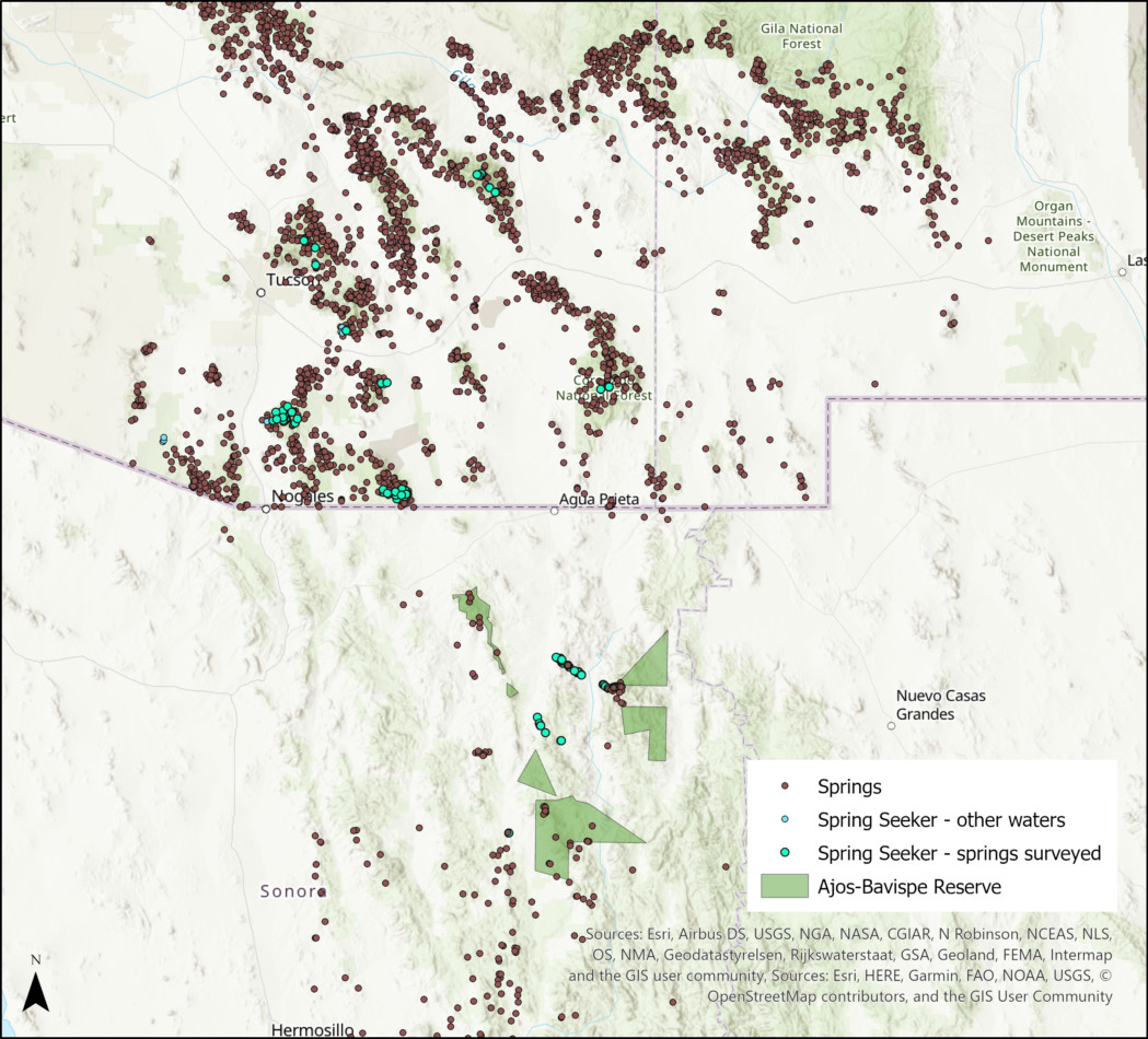
This map marks the location of springs that have been surveyed through our Spring Seeker program. The concentration of dots shows that springs are found most heavily in our mountain ranges.
Q: What plants grow around a spring?
A diversity of woody and wetland plants grow around our springs. These include these classic woody trees—cottonwood trees, willow trees, ash trees, sycamore trees—plants like sedge, rush, maidenhair fern, deer grass, seep willow, and monkeyflower, and unfortunately invasive plant species, too.
You can find a photo gallery of these spring plants at the bottom of our Spring Seeker program page.
Here is a list of the Flora Features we’ve done on spring plants so far:
Q: What wildlife do we see around a spring?
Sky Island springs can attract all sorts of animals. You may find any of the following near a spring:
- Cattle tracks or cowpies
- Wasps and other flying insects
- Birds, like canyon wrens or roadrunners
- Snails (large and small)
- White-tailed or mule deer
- Javelina tracks or signs of wallowing in the dirt
- Black bear and/or mountain lion tracks
Q: What’s the easiest way to identify a spring?
If you’ve stumbled across water and it’s not coming from a perennial stream, that’s a good sign! Check our Spring Seeker Waters map to see if you’ve found a documented spring.
If you haven’t found water, here are a few signs you can look for while out hiking or camping. These are giveaways that you’re near an underground or overground spring.
- Lots of wasps or other flying insects (they will often congregate around a water source).
- Leafy green cottonwood, willow, or sycamore trees.
- Signs of damp soil or rock, often with white mineral deposits.
- Signs of animals digging—either a hole or into the side of a hill. They’re likely looking for water.
Q: Can I go spring seeking?
We would be delighted to have you join our growing number of spring seeking volunteers! Being a spring seeker is fun, easy, safe (you can do it while social distancing), and quick. Documenting a spring only takes between 10-20 minutes to complete.
To start helping us monitor the locations of our Sky Island springs, simply download the Survey123 app onto your mobile device and use it to open our Spring Seeker survey. Once these two steps are done, no internet connection or cell service is needed to get spring seeking!
Sound good? Learn everything you need to know about Spring Seeking HERE.